Thursday, September 29, 2011

Homeward Bound; Monday September 26 - Wednesday September 28,2011


Monday brings sloshing rain, 50 MPH winds and   “ 'That Damn' Fuel Line Project.”   We start with great news from the boys who work on our boat in Seattle – by 8:45 AM, Jeff had a fuel line custom made and ready to ship on Kenmore’s float plane, arriving in Nanaimo by 1 PM.  The bad news is that due to the gusty hurricane winds, Kenmore canceled their flight for today.  The bad-bad news is that that was also their last flight of THE SEASON.
Plan B: Dan, our Harbor Master/Expert Tower, knows a guy on the island who knows a guy on the other island (Vancouver) who has the hose we need. Jim and Dan hop the ferry and within two hours they have a new fuel line, custom-made by Dan while  they're still at the auto supply store. A few new connectors, a bit of grease, a lot of muscle power and – voila!  Dan is like the Harrison Ford character in Six Days and Seven Nights – give him a Q-tip and a pocket knife, send him into the wilderness and he’ll build you a shopping mall.

Jim installs the new fuel line, bleeds the engine of air 3 times, and we start the engine up.  It looks like this might be our golden fix.  Of course, this is the third time we have tried to fix our problem, so…we are cautiously optimistic. Meanwhile, we monitor the weather web sites hourly looking for any break in the storms in which we can make our get away.


We head to the pub for supper but just today, they started “winter” hours, so by 7:15 PM, the kitchen is closed.  Dan, our new best friend, is there so we go in and sit with him and his wife, Jan, who runs the pub.  We have a beer with them and another local who lives aboard his boat at the harbor. Pretty soon three other locals join us for beers and we have a spirited conversation about politics, Bush, Perry and Obama. Most of these guys are from the states originally (Peaceniks - I love them ) and have a very sophisticated take on the state of the states. Pretty soon Jan disappears and at about 8 PM she hustles back with steaming plates of shrimp, chicken, fries, onion rings and cheese.  All on the house.  And more beer. A perfect end to a dismal day.


Sunrise Leaving Thetis Island


At sunrise on Tuesday, clear skies and light winds greet us so at 7 AM we skedaddle out of Thethis Island and five hours later we are in US waters, safely docked at our favorite place in the San Juan Islands, Friday Harbor.  This is our first trip - of the last three trips - that we actually manage to finish all on our own -  without a tow.

Sunrise Friday Harbor
Mt Baker


Wednesday is the day we make our break for home. A stunning sunrise and again, luck is on our side as the forecast for our 7 hour run looks promising all the way back to Seattle. As we leave the San Juan Islands, tons of seals put on a show for us, frolicking to and fro in front of our boat for miles. Of course every time I try to take a picture of their acrobatics, they dive under the boat. Camera shy I guess.


Once we get into the dreaded Straits of Juan de Fuca, the coast guard makes an announcement on the radio warning boaters that live firing exercises are being conducted by the US government - did they hear we were coming? - and later, that side-scanning sonar is also occuring. We make it safely through the firing range without any muzzles pointed at us.


Exactly seven hours later, we dock in Seattle - happy to be home but sad to be leaving our snug boat. We spent almost ten weeks cruising the BC waters without getting homesick or antsy. We are excellent vagabonds ready to live on board...someday.


Home Sweet Home ??


Monday, September 26, 2011

Comox to Thetis Island September 21 - 25, 2011

View from Comox Harbor


Yes, the weather has definitely changed.  It is fall with a vengeance.  We have had gale force winds - 20 - 40 knots for the past three days - and rain, needle sharp, prickly, side-ways rain.  And did I mention the wind?  At 25 kts it's enough to blast poor Zippy right into the drink.  

Jim has successfully repaired the fuel problem - we think, but won't know until we go back out and at 30 Kts of wind, that's not happening- especially since the engine quit in 0 kts of wind.  We are aiming for a Saturday departure as the winds should be 5 -15 kts. then.


Deer lounging in the park in Comox


In the meantime, we enjoy Comox but we know we have been here too long as the Harbor Master, Liz has invited us to her home.  On Friday night, our last night here, we have dinner with our new friend Gavin - the head of BC Search and Rescue - and his wife and daughter.  They send us off with fresh sockeye salmon, red wine and homemade  blackberry jam.  Provisions should we get stranded again.


Leaving Comox at Sunrise


On Saturday morning we leave Comox - again.  This is the first day without rain or gale force winds in 4 days.  We cruise out of the harbor at 7 AM sharp and 35 minutes later pass the scene of our last break down.  I hold my breath but we sail right by and continue on without incident. I resume breathing. 


Fog Rolling In


Clouds start to gather and heavy fog rolls in but we roll on.  The water is calm - I guess it's either fog and glassy water or wind, rough seas and clear skies.  Right now, radar is our eyes so we enjoy the smooth waters.  After several hours the fog breaks and we are in sunny skies - and still no wind.


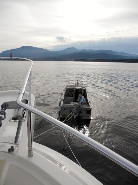
This good luck holds for 8 hours and when we can see Thetis Island, our refuge for the night, the engine stalls.  Stopped. Dead. Finished.  Over and out. Deja vue all over again.  Veterans that we now are of being engineless in the islands,  we remain calm and  call the marina.  Dan, the harbor master, says he will come get us - and he does.  In a smaller boat than our last tow, he expertly tows us in and two hours later we are safely docked.  Only then do we find out he has never towed anyone before in his life, this is only the second time he has ever driven the tow boat, it is in fact not a tow boat, and it's not even his boat.  Hmmm....


Our Novice Tower


                                                                      The Tow Boat 


                                              The Welcoming Committee


Jim diagnoses the problem - again, a plugged fuel line - and we also discover it is a defectively manufactured and or assembled fuel line.  The lawyer in me is churning and I proceed to bag the evidence and mount my legal arguments.  But clearly, this will have to wait until later as we are now stuck on an island.

Oh, and did I mention our water line sprung a geyser so we also have no water.  We're on the water, yet we have no water.  We prioritize and Jim mentions that we are now aiming pretty low when all we are wishing for is some hot water to wash our hands. But on the plus side - we have wine and now seems an appropriate time to guzzle some.   


Thetis Island with storm clouds


On Sunday, Bob,who works on the fuel dock and lives on his boat here, generously lets us use his car (no rentals to be had on the island or within 45  miles of the mainland) so we can take the ferry - $46.00 and 30 minutes - to cross to the mainland, drive to the nearest city, Nanaimo - 45 minutes away (gas $38.00) - to buy 2 feet of water hose for 5 bucks.  But hey, they have a Starbucks!  Mochas for everyone!


50 kts gale force winds are again in the forecast so we have plenty of time to figure out how we're going to get off this island.  I noticed yesterday when we were on the mainland that our "summer" cruise is colliding with Halloween - there were costumes and Halloween candy all over.  Trick-or-treat anyone?


Not Us - But Outside Our Harbor on the Rocks


Friday, September 23, 2011

Comox to... Comox, Tuesday, September 20,2011


                                                     Sunrise as we leave Comox


We are off at 7 AM,  going south to Ninaimo, on the east coast of Vancouver Island. It should be a six hour trip and the weather looks like it will be beautiful.  The water is so calm it's like we're floating on glass.  We're sipping our coffee, enjoying the scenery going by when our engine stops.  Yes, just  25 minutes out of the harbor and we have no engine.  How can this be happening - it's sunny out!

Luckily, this is one of the few times we have cell service so we put in a call to our Seattle John Deer mechanic who confirms Jim's suspicions - we have air in the fuel line.  There is no wind and we aren't drifting toward the rocky shore so Jim heads below to bleed the fuel line.  And bleed the fuel line and...you get the picture - that air ain't moving.  But now we are as the wind has picked up and is blowing us to shore, and rocks.

I call the harbor we just left and Liz, my new best friend, puts in a call to a towing company who will be here in an hour or so.  The shore is quickly approaching and Jim drops our one remaining working anchor.  While we wait, the Canadian Coast Guard comes out to see if we are OK.  I love the Canadian Coast Guard.

At 11:30 AM our vessel assist arrives,  by the name of Ata Tude - which it will need as it is 28 feet long and we are 65 feet.   


Our Rescue


 They attach a towing line and sure enough, proceed to tow us in at a brisk 5.6 knots.  Once we get to the marina - the same one we just left - they remove the towing line, sidle up along our starboard side and nudge us to our dock while I operate the thrusters to guide us.  Of course, in all the confusion of  lines, our emergency windlass handle gets caught in the towing line and flies overboard.  This is the necessary tool for pulling up an anchor should hydraulics fail.  So now we have neither of our anchors fully functional.  But that's ok because we no longer have a functioning engine to get anywhere we could anchor. 


Getting ready to pull


And there we go


One more night in Comox - we are now on such a friendly basis with the harbor master that I've added her to my contact list.  Meanwhile, our BC Search and Rescue friend Gavin, whom we met in the bar several nights ago, invites us to his house for dinner and offers us the use of his truck while we're stranded.  We may never leave Comox. Of course if we don't get this engine fixed, we actually won't be leaving Comox.


Sunset


Comox, Saturday September 17 - Monday, September 19, 2011

Heading South in Discovery Passage


We head out of April Point at 7 AM sharp to another beautiful sunrise and purple mountains majesty - and we're not even in the USA.  The only thing we need to worry about today is crossing the feared Comox Bar - a shallow channel at the entrance to Comox that is marked by buoys and range lights that "may or may not be visible" but need to be lined up on our starboard.  Sure thing.

The trip proceeds calmly for 40 minutes until we reach Cape Mudge, described by Wagoner's Cruising Guide as a "known graveyard for vessels of all sizes."  Hmmmm...


Tip of Cape Mudge with storm clouds and a strip of sun


Sure enough the waters become more roiled, the wind picks up, the clouds move in and all hell breaks loose.  Our boat starts bucking like a Texas bronco and waves the size of a Hollywood disaster movie approach.  Think George Clooney in The Perfect Storm.  But we have a sturdy boat, no need to worry, it can handle this.  But Jim can't.  Get the bucket.


Waves starting


Still, we try to stay standing and steer the boat through this when suddenly an alarm pierces the cabin and an ominous yelow light starts flashing at the helm station.  Warnings flare - "fuel derate condition" - and other words that I can't read because we're tossing to and fro.  Jim goes to the engine room to repair it but several solutions he tries fail to fix it.  And the alarm continues it's shrill blare every 2-3 seconds.

 Meanwhile, we see the anchor on the bow bounce loose from it's tie-down. Jim makes a final bucket stop  before crawling out onto the rocking anchor platform, about 10 feet above the water, to secure the anchor.  As we go down each wave, the bow slaps the surface of the water and I watch Jim ride the bow up and down.


Now, a red light flashes and even I know that's much worse than a yellow warning.  More warnings scroll across the monitor and basically, it says things are bad.  We slow down until we are cruising at about 5 knots, making this trip even longer. 


This looks Biblical


Three and one-half hours later, alarm still blaring, we near Comox and...The Bar.  I am so rattled by the constant alarm I forgot all about this little challenge.  We are now in somewhat more protected waters and the rocking and rolling has stopped, Jim is less queasy and we easily see the range lights, make the crossing and are rewarded with a glimpse of  a rainbow at shore.


Rainbow over Vancouver Island


We putter to shore, dock and turn off the engine - quiet for the first time in four hours.  After settling in we head to the bar, the real one,  for a beer to calm our raw nerves and meet Gavin, the head of Search and Rescue for BC.  Good man to know. 


Jim manages to fix the fuel problem over the next two days - which requires much effort on his part and a rented car and drive to Campbell River by me (which we just came from by boat) for parts.  We have dirty fuel that was stirred up by the extreme bucking we endured.  Jim removes from the fuel line what looks just like one of Wiley's hairballs and I eye Wiley suspiciously - I know they want to get home but would Wiley sabotage the boat???? 


Comox Harbor


Comox is a charming seaside town with cute shops, great restaurants and super friendly people.  The weather continues to be iffy and fall is definitely here - it feels like a switch was suddenly thrown.  Time to head further south before the weather gets worse. 


Our Last Evening

Quadra Island, September 14 - September 16, 2011

View of Discovery Channel from Quadra Island


Quadra Island is the northern most island we are visiting and the last island on this trip.  Of course, with a population of 2,700, it feels like a teeming metropolis compared with  Cortes Island.  It has three harbors, and we opt for April Point, on the west coast of the island.  This is a major salmon fishing area and people come from all over the world to catch their 30+ pounds of Omega 3s.

Our first hike takes us along a little used road and 45 minutes later we arrive in "town."  We have now learned that anything more than one store constitutes a town so this city center is huge with over 6 retail stores.  There is even a coffee shop that serves mediocre mochas (Howard Schultz, can you hear me?).

The next day we get our first taste of fall - rain.  Late in the afternoon it clears and we we take a short hike through the woods - startled to see real evidence of autumn - trees changing colors. 


Autumn Coming


The following morning we embark on a scooter rental mission.  The resort has Yamaha's that  are bigger than the Honda's we previously rode and they look  scarey but we want to tour the island so we forge on.  The attendant (a kid really) makes us to do a test drive to prove we really know how to drive them and tells us they are a little tricky to handle.   I feel  miffed - afterall, I  now have exactly three full hours of previous experience.  And it shows as I  maneuver the bike up a short steep hill, around a sharp curve and expertly dump it over directly into a privet.  The attendant is very solicitous - am I all right?  Did I hurt myself? - all the while  inspecting the scooter for damage.  I am fine, just fine!  But,  my pride is battered especially after he states he will not be able to rent to me.  Jim is great, assuring me he didn't like the looks of those scooters from the get-go.  I love him.

Instead, we decide to take the dinghy around the island to Quathiaski Cove where there is supposed to be a big commerical center since the ferry docks there.  The weather is cloudy and windy,  but not dangerous, so Zippy gets out-fitted in his life jacket and off we go.  The waters are rough with whirlpools big enough to swallow us and rip tides that could toss us across the island.  We are driven on by the hope of some civilization and we make it to the dock in one wet piece.  We walk up the hill and there is the exact same "town" with the same six stores we walked to days ago. 


Zippy ready to go


Painters Lodge
Our last night we take a water taxi across Discovery Passage  to our sister resort,  Painters Lodge.   Discovery Passage is used by the Alaskan cruise ships and while we're dining a mega ship sails by, lit up like a carnival.  It is so large it almost fills the entire channel.  All the diners get up to snap pictures but nothing can capture the surprising view.  A perfect final night in the islands.


Alaskan Cruise Ship

Thursday, September 15, 2011

Cortes Island - September 8 - 13, 2011

                                            
                     View Of SYC Outstation in Cortes Island from Easter Bluff


For an island that is just 10 miles wide and 20 miles long, north to south, we managed to spend five fun filled days there.  We hiked  the island top to bottom, middle to the edges, inside-out,well..., you get the point.  And still, we did not get tired of Cortes.


We started our exploration in Squirrel Cove.  Upon leaving Prideaux Haven our anchor roller broke and I was quite excited by the prospect of no more anchoring until I realized we have... a second anchor.  Oh. Yea.  So we once again dropped anchor, realized we were too close to another boat, tried to raise anchor, snagged said second anchor on something, and, well, you get the  picture.

When we were finally  settled we took the dinghy to town for provisions at the grocery store.  Even once I was in the store, I was still  looking for the grocery store.  They ended up having most things we needed but cheese is not BC's strong suit - a fact I have now witnessed many times.  Nevertheless, they had fantastic tomatoes which were turned into a tomato tart on board for dinner that night.

The next morning we left for Cortes Bay, just around the the corner from Squirrel Cove, where we docked at the SYC Outstation - it had a real live dock, with electricity and everything.  It was very exciting to finally be able to just walk off the boat instead of dinghy off.


Cortes Island from Easter Bluff


Cortes Island has a Farmers Market every Friday so we hiked  5 1/2 miles to get there.  Just  before we reached "downtown" ( a community center,  cafe, two stores, and oddly enough, one was a fully stocked health food store) there was a 6.4 earthquake on neighboring Vancouver Island.  By the time we reached the town, everyone was chattering about the shaking.  Jim and I never felt it, although after 5 1/2 miles we would have attributed any ground tremors to our noodle legs.

The Farmers Market had neither farmers, flowers, fruit nor produce.  It did have an abundance of amazing baked goods and we loaded up.  Luckily, a couple we had met at our marina was there by car and gave us a ride back. 

Our days here could best be called The Invasion of the Mosquitos.  They were so viscious we had to close the windows and lock the doors.  Jim spent one evening doing a mosquito round-up with his trusty electric zapper - after 30 were downed, he  quit counting, but the bloodbath continued.  Bees plagued us as well.


                                               Bees: An Official Menance


We did a lot of hiking on Cortes Island.  One climb was up to Easter Bluff, the highest point of the island at 705 feet - but it felt much higher as we climbed.  Zippy was like a billy goat, leading the way up.


We also hiked to Whaletown - a tiny little port that had only two businesses, a US Post Office and a libraary.  Neither of which were open in the middle of the day, in the middle of the week.  Nor did they have posted hours.  Nor did they look like they ever opened.


                                                          Post Office


                                                                Library


By day 3 we had to escape the mosquitos so we  took our boat around the corner and north to Gorge Harbor, also on Cortes.  There we embarked on several hikes, one through the woods and around a lake.  Let me be clear here about these hikes.  This is not a stoll on a grassy neighborhood path - this is hand to hand combat with boulders and trees on hilly, rocky terrain.  Shortly into our climb, we saw a sign warning of black wolves in the woods.  We knew there was a wolf population on the island, we didn't expect that they lived in the very area we were now hiking.  But, sure enough, we saw numerous wolf droppings along our path.  We were warned of cougars too, but luckily can report we saw none.


Entrance to Gorge Harbor


Our march through the woods and around the two lakes  lasted much longer than we imagined and we ended up in a different place than we expected, the signs were most unclear. Essentially we ended up back near Cortes Bay where we were moored the previous day.  By the time we walked back, through town and got back to our boat, we had probably walked the island twice over, vertically and horizontally.  And it took us all day to do so.


                                                        No Wolfs - but eerie


Gorge Harbor


Gorge Harbor has a wonderful restaurant and we had two amazing dinners there.  Our waitress, Rose, regaled us with stories of life on the island.  The population is 950 permanent residents, which swells to 3,500 people in the summer.  The residents are mostly new-age hippies and artists.  Many don't have septic systems or wells.  She explained it this way: people prioritize their living needs.  Islanders chose windows over water, water over septic systems.  Thus, many people live without running water and with out-houses.  There is no cable or satellite TV and she believed creative thinking was more abundant on the island because of this.


We could actually spend several more days here, there's a few more places we haven't hiked but, all good things must come to an end, so tomorrow we will head north for Quadra Island.


Wednesday, September 14, 2011

Desolation Sound - September 3 - September 6, 2011

Entering Desolation Sound


Let's call these days "As the Anchor Turns."  Desolation Sound is part of British Columbia's largest marine parks and the most remote area we have been.  It has over 37 miles of pure wilderness accessible only by boat and not even hospitable to hiking.  The shores are steep rocky slopes leading to craggy hills  leading to boulder-ed  cliffs.  In other words,
there are no marinas, there are no docks to tether to - there is only... The Anchor.


Grace Harbor


Our first three nights are spent in Grace Harbor where we are surrounded by tree covered hills and complete silence - no cars, no planes, no city din.  There are no sounds other than a boat or two put-put-putting to and from the harbor. And of course the sound of us dropping anchor...only the second time we have anchored in the Pacific Northwest. 

We enter the harbor and nab a spot between two other boats.  Jim successfully drops the anchor and chain loudly spills out.  It bites and we are done.  Wait, are we swinging too close to the other boats?  Yes, definitely.  We must raise anchor and move.  Slowly we circle the harbor stalking spots that are not too close to the rocky shore or other boats.  There is no room for us so we decide to leave.  Just as we're  exiting the harbor, we spy a possible space and head back in, first positioning here, no, not quite right, let's go there.  Back and forth several times until we agree on the perfect spot.  Other boaters are now watching us, bemused.  Jim again lowers the anchor, it bites - done.  We are in exactly the same place as where we first started.


Zippy's Business Center


Next, we launch the dinghy to chauffeur Zippy to do his business.  Because the shore is so jaggy and the water leading to it so deep, finding a spot to moor the dinghy is challenging and accompanied by much colorful language from the Dinghy Captain.  When we finally stumble upon a spot where we can ram the dinghy onto shore, it requires a contortionist to actually get out of the boat and hold us.  Jim  gets one foot out, into the water, balancing  on a slime covered rock, his other leg still in the dinghy which is now floating away with me and Zippy.  His splits earn a 9.5.  This routine is repeated 3 times daily and is complicated when the tide has gone out, sometimes 10 - 12 feet.  Then Zippy and I get to step in cold water and scramble up the oyster shell-strewn, ragged, jagged shoreline - all before my morning coffee.


The Chaffeur


 Our isolated stay is not all primitive hunting and gathering.  The Laughing Oyster Restaurant is a 25 mintue dinghy ride away and we decide to head out.  The ride there is spectacular, and so is the food.  Quite possibly the best dinner we have had since leaving Seattle.


The Government Dock at Laughing Oyster


The View - So Beautiful It Hurts my Eyes


Our Dinner


Prideaux Haven is our next stop and it is even more beautiful, considered the jewel of Desolation Sound.  The anchoring goes very smoothly - the first time out.  After we are safely tethered we board the dinghy and head out to explore.  On our way back to the mother ship another Selene enters the harbor and it is our friends Kathy and Mike from Elliott Bay in Seattle.  You just never know who you'll run into.  It's their 40th wedding anniversay and our last night here  is spent under a full moon celebrating with them. 


Prideaux Haven


An evening in Desolation Sound


Starfish at low tide


I'm getting adjusted to anchoring and feel confident that we won't drift away. I"m still not used to swinging 360 degrees in a circle, over and over.  It's disconcerting to glance out the window and see a completely different view every fifteen minutes - but then again, it's like being anchored in 360 different places - without moving the anchor.  That I like. 


The Grandeur of Desolation Sound