Saturday, June 27, 2015

El Capitan Passage and Cave, June 13, 2015


El Capitan Passage
 
Awww
El Capitan Passage is the northwest end of Prince of Wales – clearly the best is last.  The 25 mile channel, north of the aptly named Sea Otter Sound, is in fact, littered with otters.  Traversing this passage is like playing whack-a-mole, no matter which way we turn the boat to avoid them, they pop up in front of us.  When we’re not dodging them, we take in the breathtaking beauty of this cliff and forest lined passage. 

 
Our first anchorage is in a beautiful bay just northwest of the El Capitan Cave.  We are here to take a guided tour of the underground cave that was discovered in the mid-1990s.  Over 2 miles of it have been mapped by archeologists and paleontologists.  Our guides are two interns for the National Forest Service, both studying to be geologists.   Ana and Matt are very knowledgeable and since we are the only two people on the tour, we get to plumb the depths of this knowledge.

View of our boat from top of the stairs
 
 
We meet at the bottom of the 370 steps for the steep ascent through the forest to the cave.  We don hard hats with lamps and rain gear since this limestone cave weeps water.  It is a 70 degree day and when we get to the entrance of the cave, you can feel cool air pouring out.  Ana said you seldom get to feel the cave “breathing” because it is usually too cool outside to notice this temperate difference.


Ready to enter the cave
Upon entering, we encounter a locked gate to prevent intruders from trespassing.  Matt opens it and after we go through he pad locks it behind us for reasons unclear to me.   Matt assures us he has bolt cutters should we need them.  Suddenly, I wish we had asked to see their IDs, anyone can put on a green shirt and claim they’re a ranger.  Come to think of it, neither of them is wearing a ranger uniform or insignia.  Well, too late now – we’re locked in.
 
 
The floor inside the cave is uneven and rocky and the only light inside this tunnel is cast from our lamps and flashlights.  There are crawl spaces everywhere leading to other levels of the cave, some fan up, others down.  Our guides have spelunked some of them. 


Yikes

Our guides look so harmless now that they have unlocked the cave gate
The limestone walls are covered with mineral deposits that look like frosting.  Parts of the ceiling have hundreds of water droplets that glisten like diamonds.  These are filled with minerals that will eventually harden to become part of the stone surface.   At the head of the cave we turn off all our lights and “listen” to the cave “talk.”   I don’t hear it say a thing but I do hear some dripping water and feel a splat of it on my face.  Even though I am slightly claustrophobic, we have loved the tour and are sad when it’s  over -  but greatly relieved when the locked gate is opened.

West Coast Prince of Wales Island, June 9 -12, 2015


Stormy, fogy, yuk
 
Traversing the southern tip of Prince of Wales,  we enter the stormy waters of the Gulf of Alaska.   Being a fair weather boater, I am not a fan of these open waters but luckily, we don’t get thrown around and are soon in the protected passage of Cordova Bay.  The west side of Prince of Wales is comprised of beautiful, remote anchorages and some quirky towns.  We sample it all – stopping one night in Kassa Inlet where we forage for our dinner and catch 24 wonderful prawns. Shrimp Scampi for dinner.

A Hydaburg House

An afternoon stop in Hydaburg is on the agenda.  This is a native Haida village (population approximately 370) known for their extensive totem park.  We meet Hagu, a native elder, who gives us a tour of their carving shed and regales us with the “story” of his people and the suffering they endured at the hands of “the white man.”   He clearly relishes his unending presentation and when we tell him we have to skedaddle, he thrusts a tomahawk into Jim’s hands and has him beat the Indian drum as accompaniment to a native song he sings for us.  I think we’d still be there if Jim had been able to carry the beat.
 
View from above Hydaburg house


Craig is the largest town on Prince of Wales (population approximately 1,200) and is the service center for the island.  There is a bank, fully stocked grocery store that serves the entire island, and more B&Bs and hotels than you’d see in a quaint New England town.  Sport fishing is the draw here. 
 
Craig Hotels
 
My question:  where does everyone eat? There is a cafe and one restaurant/bar in town - Ruth Ann’s– open Monday through Friday.  The bartender, a beautiful, buxom blond, explains that this is a real problem as there is nowhere to go on date night – Saturday & Sunday nights.  I see the dilemma but am much more interested in the fact that this woman has her makeup so expertly applied it’s almost as if she has a team of New York stylists stashed behind the Jamieson whiskey.    And where did she get the makeup?  There is no place on Prince of Wales Island that sells it, save for what she can scrounge up at the local pharmacy.  In fact, there are no department stores, Targets, or even a Walgreen in all of SE Alaska – well, there is a Fred Meyers in Juneau but that is a boat or float plane away. And the pharmacies’ makeup isles are usually a shelf or two of random products.  At any rate – she looks great and I can see why she worries about where to go on date night.
But there’s always the hardware store, and oh what a store! There, Jim gets an espresso mocha - it's a full service hardware store.  Now there’s an idea for a date night.


On the way to Craig

Thorne Bay, June 1, 2015

Thorne Bay


Living off the grid
Prince of Wales Island, west of Ketchikan, is reputedly the third largest island in the U.S., much of its land is in the Tongass National Forest. We decide to circumnavigate the island and our first stop is Thorne Bay.  The charts and guide books are a little sketchy on where exactly the harbor is once you enter the bay and since there is a fork in the waterway with two large arms going in opposite directions,   I call the harbor number listed and ask whether they are in the NW arm or the SE arm.  A city employee who answers does not know.  Huh. 

We follow our instincts, head up the NW arm and finally, around a bend, we see the small harbor.  I radio the harbor master and he’s waiting for us at the dock.  He could be Matthew McConaughey's better looking younger brother.  We have been in many harbors, big and small, and he is the most professional harbor master we have encountered.  He gives us precise docking information (“you are 10 feet from the dock” versus the usual “ok, a little more this way” – what way????) and expertly handles the lines.  As I jump off the boat to tie the stern line, my headset transmitter falls into the drink.  Matthew – also known as Shane – drops to the dock like a Hollywood stunt man, dives his hand into the water and scoops up the radio before it even has time to think about sinking.  He leaps up and presents it to me, his baby blue eyes twinkling.  I love Thorne Bay.

A sight seeing excursion is called for so we stroll the town (approximately 400 residents) which a local tells us will take all of ten minutes.  It takes fifteen.  The town is stepped on a hill and we walk up and down, back and forth.  Unlike Ketchikan or Juneau, where the road ends when you reach the edge of town, this road actually continues, crisscrossing the island to other towns and destinations.  This is so exciting.

There is a lookout at the top of “Heart Attack Hill” – so dubbed by the locals - and we take this as a challenge.  Expecting a goat path, with rugged rock outcroppings to clamor over, we instead find  a maintained footpath with occasional stairs.  But the view from the roughly 300 foot elevation is so spectacular that this is what they must have meant by “heart attack.”


Our evening ends with dinner on the fly bridge and a Nat Geo show  – our own live presentation.  Approximately fifteen eagles are at shore scrounging the tidal flats for fish and clams, strutting, chirping, arguing, and generally entertaining us for 
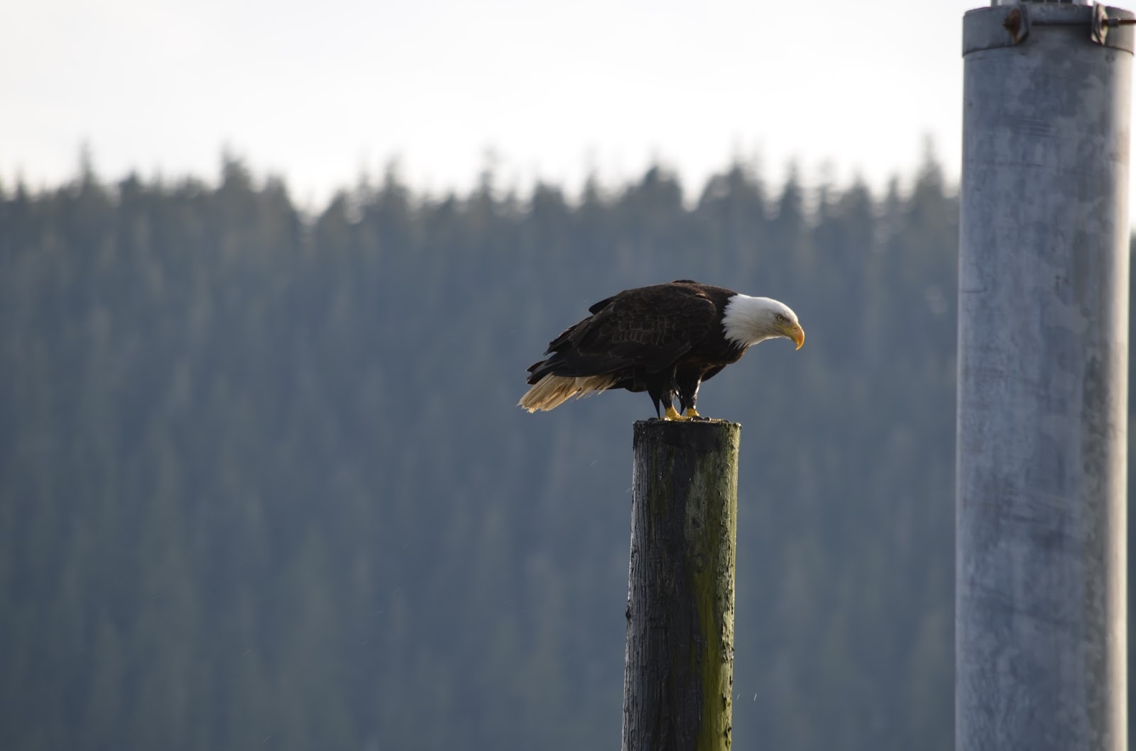
over an hour.  One eagle flies over to glare at us, perching on a piling smack next to the boat.  We are a little unnerved by his unflinching eagle-eyed stare and frantically hustle the cats indoors.  He is watching his own Nat Geo show.
 
 
Moonrise in Thorne Bay


Tuesday, June 16, 2015

Petersburg, May 29-30, 2015


Approaching Petersburg

“Little Norway,” or Petersburg, as it is officially known,  is located on Mitkof Island and  was founded by Norwegian fisherman.  And they take their heritage and fishing seriously.  The harbor is filled with large fishing boats and many of the town’s buildings have the traditional "rosemaul" Scandinavian designs painted on them. 


Housing for summer fishing fleet employees
  But for a town of approximately 3,000, they have no evening restaurants to speak of.    
There is the pizza place, it closes at 8PM – no alcohol served;  the taqueria stand with only outdoor picnic tables for seating - they close at 7 PM;  and finally, the fish taco shack, with only outdoor picnic tables, and they close at 8 PM.  
Taqueria


Bingo on Friday Nights! After Hamburgers   
This is a big topic of conversation among the boaters who visit.  When I asked the harbormaster why there are no restaurants she explained it this way:  “Everyone believes that their mother makes the best fish cakes, so I don’t want to eat your fish cakes.”   I actually don’t want to eat anyone’s fish cakes but still,  what happens when you get sick and tired of always having to make the fish cakes?  “We go to the Elks Club on Fridays for hamburgers.”


Slacker Seals


But fine dining is not what brings us here, nor the sporadic cell phone coverage or the intermittent internet, no, it is fishing, natural beauty and nearby LeConte Glacier.  


LeConte Glacier
Bergie with Seals
 This glacier is 21 miles of the bluest ice you can imagine.  The bay leading to the glacier is strewn with bergie bits (chunks of ice,) some as large as a Volkswagen, that “calve” off the bottom of the glacier and then pop up in the bay, glittering like diamonds.  Seals birth on the cold ice bergs and eagles come to feast on the afterbirth - at least someone is getting fine dining.  


Meyers Chuck, May 26, 2015

Meyers Chuck


Magical and enchanting – that is the only way to describe this rocky peninsula accessible only by boat or float plane.  Located about 30 NM north of Ketchikan, it is remote and the 20 or so residents like it that way.  Houses are perched on a hill connected by a single-file trail skirting the edge of the peninsula -  the only passage to explore this area – so we march past the owners’ property – we think – boundaries here being a very loose concept.  We pass a closed art studio/store in a small painted shack.  A sign posted on the door states that they’ll open if you call the phone number listed, but that is not necessary to see great art – whimsical sculptures are scattered everywhere.


We have our friends Rich and Shari with us for a week and the four of us head for the woods, following the well maintained trail, and reach a clearing between the trees.  The evergreen canopy is thick and although it's dark, we immediately spot the rustic playground nestled here.  Like second graders at the sound of the recess bell, we rush for the slide, its shinny aluminum surface burrowed in the hill, and shoosh down, landing with a thud on the forest floor.  Maybe we ought to stick with the 40 foot log teeter-totter which merrily bounces us until our backs scream “get off.”  We wisely pass on the rope monkey bars.  


The head of the peninsula near the dock used to have a pay phone, but it’s gone, only a bulletin board remains, posting items for sale.  The post mistress – yes, there is an official post office, reachable by dinghy - used to moonlight as a baker, creating fresh cinnamon rolls and delivering them at 7 AM by dinghy - but her sign is gone too.  Disappointed, we trudge back to the boat and comfort ourselves with fresh baked banana bread – boating can be a real hardship.

 
Evening in Meyers Chuck